Saturday, January 27, 2007

Community Mapping, Participatory Landscape Analysis & GIS Training Workshop

Tired. Very tired. I have just spent the last two weeks conducting a Geographical Information Systems (GIS) training workshop with my office, PSTEO, and some people from the District Agriculture and Forestry Office (DAFO). I have never seen my Lao counterparts get so excited and put so much effort into any activity we have conducted before. Usually, when you hold training, people tend to show up around 9am (if you scheduled to start at 8am), take a half an hour coffee break around 10am, and leave for lunch around 11:30. The afternoon usually gets going around 2 or 2:30 and everyone disappears around 4. This time around, people were showing up at 8am, no coffee break, and not leaving for lunch until 12:30! They were back like clockwork by 1:30 and many days we didn’t leave the office until 6 or even 7pm. Pretty incredible to say the least. It’s been a lot of fun as a result but very tiring as we have been keeping this schedule for the last 12 days straight.

The objectives of the training were as follows:

To provide participants with a basic understanding of the theory and practice of Geo-informatics and remote sensing
To provide participants with basic understanding and knowledge in the use of Arcview 3.2a (a GIS software package used for making maps and displaying spatial data)
To enable participants to conduct participatory community mapping (PCM) in villages with respect to land use and watershed management
To enable participants to correlate and confirm data taken from the PCM activities using baseline spatial data taken from external sources, and by using a Global positioning system.
To provide participants and PSTEO and DAFO the means and capacity to integrate basic GIS skills and knowledge into the planning and implementation processes regarding land use planning and watershed management

Activities

The first week we spent in a meeting room at the PSTEO offices with a GIS expert we flew up from Vientiane from the National Agriculture and Forestry Research Institute provided an introduction to GIS and using Arcview to make simple maps. Participants learned how to:

Create maps in arcview using base line data from NAFRI showing watershed boundaries and catchments, watershed classification, infrastructure, hydrology, land use planning, geo-referencing data, and displaying all this data in map layouts.

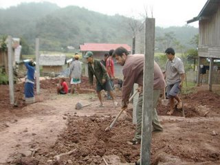
The second week, we headed out to a village (Ban phonhom) to conduct the PCM and participatory landscape analysis aspects of the training. Participatory mapping is conducted by using large (A0) base topography maps developed showing a digital elevation model with hill shading and contours. Over this way lay a transparent piece of paper and then work with the villagers to draw the village boundaries and all current land use activities. Also, the training workshop participants went into the field with the villagers and, using a clinometer, compass, and gps unit they learned to calculate slope and identify areas of the village that were susceptible to high erosion and sedimentation and thus potential risk areas to watershed functions and services. This took three days and ended, of course, with a big lao hai drinking party. (who would a thought!)

Once the field work was completed it was back to the office to digitize the maps we had made in the field. This is done by geo-referencing the transparent maps in Arcview overlaid with the gps data. What you end up with is a digital map of the transparent maps made by the villagers, which we can then overlay with the data given to us by NAFRI. This is what we just finished doing. The next step after the training will be to take all this data and use it to develop future strategies and land use and watershed management plans.

Overall, I have to say this has been my favorite workshop so far and can also say my own knowledge of GIS and arcview has increased tenfold.

Tuesday, January 16, 2007

Shifting Perspectives Continued...

One night, while dining over “sin-daat” (a form of Lao BBQ) with a colleague, we were discussing this very situation when my friend asked me a simple, yet poignant question, “How is it that a form of agriculture such as the shifting cultivation, which has practiced by the Khmu people in this area for the last 400 to 600 years, was suddenly deemed un-sustainable?” Of course, as usual, I had no answer. I knew one thing for certain: I needed to find out. For me this was the starting point when my perspectives and understanding of upland agriculture began to shift.

Shifting Cultivation in Laos-traditional and current circumstances
Shifting cultivation, as it has been traditionally practiced by the Khmu, and other ethnic groups in the north of Lao, is far more complicated than the simple images portrayed by slash and burn.

Firstly, it is important to understand why upland agriculture is necessary to begin with. Oudomxay, like the rest of the country, is a highly mountainous area, comprising around 80% of the total land area. The geography is characterized by steep sloops, rugged terrain, and very little lowlands and flood plains. The fact of the matter is that Oudomxay has very few options or viable alternatives to cultivating upland areas. Even if they cultivated every square inch of lowland areas for rice paddies (they would have to get rid of all the towns, roads, etc to do so) and managed to raise production levels by 20% or more, they would still be faced with rice shortages to meet the demands of a growing population. This means that upland cultivation, in one form or another, will remain apart of the agricultural landscape, and a crucial aspect of the people’s livelihood strategies for some time to come.

The fact that shifting cultivation has been stigmatized and associated with poverty and “backwardness” is a classic example of what has come to be called environmental racism: the placement of blame for environmental degradation on often marginalized ethnic minorities. There is a danger of course of oversimplifying or romanticizing the lives of shifting cultivators. Upland agriculture, though an effective livelihood strategy, is a difficult one. I once asked the Phorban (village chief) in Ban Tangnuey if he felt the village was better off living in the valley bottom doing sedentary agriculture as opposed to their traditional lifestyle in the nearby hills. He answered that yes, he did feel the village was better off. Why? Because living on a hill is difficult he replied. The fact is that many of the villages I have visited and worked in usually expressed a willingness to move away from shifting cultivation if provided the opportunity. They would like to practice different forms of agriculture; they would like access to schools, hospitals and infrastructure. The question is how the programs are carried out and what their true intentions are. I have come to suspect that the efforts to eradicate shifting cultivation have less to do with “improving” the people’s lives than getting them out of areas that are rich in other resource values such as timber, mining, and cash crop plantations. This leads us to another key point, that even if shifting cultivation was recognized as a viable form of agriculture, the fact is the Khmu people live in a very different socio-economic environment than they did in the past. There is a much higher degree of competition over land uses. Shifting cultivation, as practiced in the past, meant that people had to move around every 20 years or so…this may not be possible with a growing population and demand for cash crops and resources.

Seeking out the Environmental Culprits
So, if shifting cultivation isn’t the cause of all the environmental degradation, what is?

Well, let’s first clarify that there isn’t one single cause of environmental degradation. Secondly, it’s important also to clarify specifically what environmental degradation are we speaking of. My research with the Oudomxay Provincial Science Technology & Environment Office in the Ko River watershed, along with a growing body of secondary research being conducted by numerous domestic and international research institutes, has provided a fairly comprehensive picture of the state of the environment with respect to watershed functions and services. (Please see the inserted graph.)

As I stated before the only thing that matters in ecology is the rate at which something occurs and the timeframe in which it occurs. Shifting cultivation, as practiced in the past, with long fallow periods, has been shown to be either environmentally benign, or even beneficial. Currently however, the state of shifting cultivation is rapidly changing due to changes in land use policy, as discussed earlier there are much shorter fallow periods and increasing intensity in the use of land in increasingly fragile environments. One could accurately describe this form of agriculture as “pioneering” cultivation and it is a major source and cause of soil erosion, sedimentation, deforestation, and storm water runoff; a major source of environmental degradation in the province.

It is not the only culprit however. A growing consensus among agronomist, planners, and development workers and agencies, is that the most significant cause of environmental degradation in Oudomxay and Lao generally is the issue of land use change, the growing rate of conversion of forest and agricultural land to large monoculture cash crop plantations, particularly rubber. Throughout Oudomxay province we are seeing larger and larger areas of land being cleared and planted with massive plantations of rubber. The large majority of the investors come from China and they have very little interest in conserving the land for the long term. Quite often, the land is given away in concessions to investors, land that typically belonged to villagers—the land taken away and given to the investors without consultation or even the knowledge of the farmers. These plantations have incredibly high erosion and run off rates, and typically can leave the soil denuded and useless for many years afterwards. Other land uses that can prove damaging to watershed services include stripping the vegetation along rivers and streams to grow corn and other crops, and the destruction of and loss of wetlands and floodplains. Once you put all these issues together you are looking at a very severe degree of environmental degradation. Quite obviously the issue is very complicated and defies any simple explanation or solution.

Thursday, January 11, 2007

Integrated Spatial Planning Workshop

Hello, well my new year got off to a bit of a rough start concerning all things computer. on the 2th my computer was obliterated by a virus which erased all my systems files. Luckily I was able to recover most of my files and had everything else back up...except for some of my writings including the finished essays on shifting cultivation...so you'll all have to be patient while I rewrite those. right now I'm actually in Khon Kaen Thailand just over the border from Vientiane taking part in a workshop on Integrated Spatial Planning with a number of guys from my office and other governent officials from Oudomxay Province. It's being held by some international consultants being funded by the Swedish International Development Agency. So far it's been a really interesting workshop and I'm learning a lot of new planning skills and it looks like I'll be playing a key role in implementing the pilot project for oudomxay to develop and implement a integrated spatial plan for the the province. I'll get more into what spatial planning is etc another day...for now I must go and....wait for it....wait for it....drink beer! bet you never saw that coming! Ok, cheers, patrick