Tuesday, May 15, 2007

Back in Canada

Well, it's finally happened I have found myself back in Canada after more than two years of working and living in Lao. Now I get to have the fun of experiencing home shock. First thoughts, everything is very big here...cars, parking lots, grocery stores, cereal boxes...waist lines. Everything. Currently I have no real idea as to what's going to happen next. My grand plan of having a plan has gone up in smoke due to a startling lack of planning--there never was a plan. Ah well, I think I'm going to take the next few weeks, relax, do some research and then figure out what I want to do next. For sure, my foriegn adventures are hardly over. I know for sure that I would like to continue working overseas and facilitating community based efforts in identifying environmental threats and risks, and working towards developing practical and effective plans and strategies to address them. Honestly, I'm hooked with the south and I certainly see myself in Lao again in the near future.

In the next few months keep an eye out, both in Canada and overseas for new activities including publication of articles of my experiences, a photo exhibit with Paul on our photodocumentary in Lao last year, and more projects. I will be sure to keep everyone updated. Until then, sok dii lae pob gan mai. Good luck and we'll meet again. Patrick

Saturday, February 03, 2007

Shifting Perspectives—Conclusion

Finally, this brings us to the second Development Riddle, which is: When is a problem not a problem? Answer: When it is part of the solution.

Understanding a social system is not unlike looking at a computer drafted 3 dimensional picture. You may remember these were all the rage about ten years back. At first glance they appeared non-sensical, chaotic, a meaningless mess of objects and patterns. But, if you look long enough, and adjust your perception or perspective accordingly, an image will emerge. Understanding shifting cultivation within the contemporary context of Lao is a very similar process. Once you look past the smoke and the fires, the charred and burnt fields and trees left behind, you can begin to see it in a very different light. Rather than being backward and primitive, shifting cultivators have developed highly in-depth agro-ecological knowledge and management systems that have resulted in Lao having some of the highest biodiversity levels in south east Asia, an incredible genetic heritage of rice species perfectly suited to the local growing conditions and environments, not too mention a huge abundance and diversity of non-timber forest products, all of which make a substantial argument that shifting cultivation can be sustainable. The government of Lao, and all actors and stakeholders should appreciate this as highly valuable asset that is quickly being lost, not as a threat. For too long, shifting cultivators have been blamed for environmental degradation and have been resettled and made to alter their livelihood strategies regardless of whether there were adequate or viable alternatives or whether the promised services and infrastructure could be provided. The underlying assumptions have been that shifting cultivators are invariably poor and therefore any move to improve their lives will inevitably result in greater prosperity. Unfortunately, this has not been the case. These assumptions ignore the vast natural wealth that many indigenous communities possess within their traditional environs. Moved into new communities, cut off from traditional land use practices, provided inadequate land with little training or extension workers and credit, many families and whole communities are falling into new poverty cycles that are difficult to reverse or escape. All of which is leading to higher levels of environmental degradation. Obviously, this cycle must end and development and government agencies need to start looking at shifting cultivation in a new light.

Back in the day, while fighting their “Secret War” in Lao, the CIA had a saying, “If you think you understand the situation, you simply don’t have all the facts!” The fact is that Lao, like any country or culture anywhere in the world I suppose, is far more complicated and dynamic than even a 3D picture. Anytime you think you are starting to figure things out, some little fact jumps out and shatters everything you built. I won’t presume to truly understanding the entire situation as there is no way that I could ever have all the facts. But I have identified a few important facts that can guide future action.

1. Shifting cultivation, if done properly with traditional or effective contemporary soil erosion methods, and sufficiently long fallow periods, can be not only environmentally benign, but beneficial by encouraging new growth and higher biodiversity.

2. Shifting Cultivators do not deserve the stigma or stereotype of being either backwards or poor if they are successfully practicing their traditional methods. (Successful in my opinion, for this circumstance, being that they are meeting the requirements of the first point, while supplying all the nutritional and material needs they require for sustainable economic and social security.) Shifting Cultivators possess in-depth agro-ecological knowledge that, while it should not replace solid scientific knowledge and research, it should be respected and viewed as an asset.

3. Shifting Cultivation does not equal environmental degradation—so long as it meets the requirements of the first two points. There are other sources of degradation that must be addressed together, including: pioneering cultivation, deforestation, large rubber plantations, intensifying agriculture in the low lands, all of which result in soil erosion and sedimentation, and drastic changes in the hydrological regimes of watersheds (ie. Flooding, droughts, etc.)

So where does all this leave us?

It’s one thing to say that the government, NGOs, and development agencies should stop demonizing shifting cultivation and view it as an asset: a major barrier that must be crossed, but what are they supposed to do then? Seems to me to there are plenty of people around doing this first part, but I have yet to see any concrete actions plans, strategies or criteria for planners to work with to actually start integrating in a sound manner into the contemporary planning process and agricultural landscape. All of this assuming of course that shifting cultivators want to keep practicing shifting cultivation. As always, it’s easy to criticize and point out mistakes, it’s a completely different situation altogether to come up with feasible and practical solutions. This is the next step and the entry point for planners, such as myself, have to step up to the plate.

Fortunately, there are some people and agencies who are working on this issue, and within my limited time and experience in Lao I have begun to gather some ideas to approach this issue. Firstly, there are a few preconditions that must be met. Some of these include:

There must be a recognition and understanding by all stakeholders and agencies that:
a. Shifting cultivation with the appropriate fallow periods and practices is not inherently environmentally destructive or unsustainable
b. That without viable and feasible alternatives and means shifting cultivators cannot be expected to change their practices and that shifting cultivation can remain a reasonable and sustainable means of sustenance
c. Adequate land and low population densities conditions must exist to allow for environmentally acceptable practices. (Some have suggested areas with less than 20 persons per 1 km2, may be an acceptable population density to allow for sufficient fallow periods…assuming there are no other practices or land uses in the area…not likely for most locations.)

As I said before, there is a growing awareness and consensus among planners (both Lao and foreigners) that the eradication of shifting cultivation is not only undesirable under current economic and social condition, but highly unlikely for the foreseeable future. In fact, the government of Lao has begun to change its language from a program of “eradication” to “stabilization” wherein shifting cultivators are encouraged to change, but are allowed to practice in limited areas as long as it does not encroach on current forest covered areas. Regardless, I have compiled a short list of strategies and objectives I have been encouraging people to consider throughout my tenure as project coordinator for the Nam Ko Watershed Project, these include:

1. Improve Land Tenure, Land use planning & allocation.
Existing land entitlements in Lao are weak and routinely ignored by government officials. It is far more likely that farmers will engage in sustainable agricultural practices if they have a more secure knowledge that they will have access to the land over a set period of time. Also, by improving upon the land use planning and allocation process, the government will be able to alleviate conflicts and deal with environmental problems more effectively.

2. Improve Fallow Periods & Recognize Fallow as a legitimate form of land use.
Currently, the government of Lao has a regulation in place that if a farmer does not use his land for a period of three years (ie. Allows it to go fallow), than he or she will use their land use certificate. By recognizing fallow as a form of land use, they will provide more opportunities for the regeneration of soils and harvesting of non-timber forest products.

3. Implement development programs that are people centered.
Many development projects have been implemented in a top-down manner focusing on broad development goals that have little to do with the needs and realities of local communities. Local residents should define and establish needs and criteria for development as well as evaluating successes.

4. Ensure provision of viable alternatives to shifting agriculture
Should upland communities choose to relocate and shift from traditional agricultural practices, this should only be done when there are viable and feasible alternatives. Obviously, this is a classic “Chicken and the egg situation”. The government, and development agencies need to recognize that this process will not happen overnight and that traditional methods should not be cut off or disallowed until alternatives are firmly in place and providing for all the needs and requirements of the people that were available from traditional practices and more.

As I have said, this is an extremely complicated situation, and I’m sure that within a few years time, or even in a few months, my own understanding and perspective of the situation will change and continue to evolve…or at least I hope so. I can say with some confidence that I have been learning thus far, as when I look back on what I thought to be true in the past…it was, indeed, pretty much completely wrong.

Saturday, January 27, 2007

Community Mapping, Participatory Landscape Analysis & GIS Training Workshop

Tired. Very tired. I have just spent the last two weeks conducting a Geographical Information Systems (GIS) training workshop with my office, PSTEO, and some people from the District Agriculture and Forestry Office (DAFO). I have never seen my Lao counterparts get so excited and put so much effort into any activity we have conducted before. Usually, when you hold training, people tend to show up around 9am (if you scheduled to start at 8am), take a half an hour coffee break around 10am, and leave for lunch around 11:30. The afternoon usually gets going around 2 or 2:30 and everyone disappears around 4. This time around, people were showing up at 8am, no coffee break, and not leaving for lunch until 12:30! They were back like clockwork by 1:30 and many days we didn’t leave the office until 6 or even 7pm. Pretty incredible to say the least. It’s been a lot of fun as a result but very tiring as we have been keeping this schedule for the last 12 days straight.

The objectives of the training were as follows:

To provide participants with a basic understanding of the theory and practice of Geo-informatics and remote sensing
To provide participants with basic understanding and knowledge in the use of Arcview 3.2a (a GIS software package used for making maps and displaying spatial data)
To enable participants to conduct participatory community mapping (PCM) in villages with respect to land use and watershed management
To enable participants to correlate and confirm data taken from the PCM activities using baseline spatial data taken from external sources, and by using a Global positioning system.
To provide participants and PSTEO and DAFO the means and capacity to integrate basic GIS skills and knowledge into the planning and implementation processes regarding land use planning and watershed management

Activities

The first week we spent in a meeting room at the PSTEO offices with a GIS expert we flew up from Vientiane from the National Agriculture and Forestry Research Institute provided an introduction to GIS and using Arcview to make simple maps. Participants learned how to:

Create maps in arcview using base line data from NAFRI showing watershed boundaries and catchments, watershed classification, infrastructure, hydrology, land use planning, geo-referencing data, and displaying all this data in map layouts.

The second week, we headed out to a village (Ban phonhom) to conduct the PCM and participatory landscape analysis aspects of the training. Participatory mapping is conducted by using large (A0) base topography maps developed showing a digital elevation model with hill shading and contours. Over this way lay a transparent piece of paper and then work with the villagers to draw the village boundaries and all current land use activities. Also, the training workshop participants went into the field with the villagers and, using a clinometer, compass, and gps unit they learned to calculate slope and identify areas of the village that were susceptible to high erosion and sedimentation and thus potential risk areas to watershed functions and services. This took three days and ended, of course, with a big lao hai drinking party. (who would a thought!)

Once the field work was completed it was back to the office to digitize the maps we had made in the field. This is done by geo-referencing the transparent maps in Arcview overlaid with the gps data. What you end up with is a digital map of the transparent maps made by the villagers, which we can then overlay with the data given to us by NAFRI. This is what we just finished doing. The next step after the training will be to take all this data and use it to develop future strategies and land use and watershed management plans.

Overall, I have to say this has been my favorite workshop so far and can also say my own knowledge of GIS and arcview has increased tenfold.

Tuesday, January 16, 2007

Shifting Perspectives Continued...

One night, while dining over “sin-daat” (a form of Lao BBQ) with a colleague, we were discussing this very situation when my friend asked me a simple, yet poignant question, “How is it that a form of agriculture such as the shifting cultivation, which has practiced by the Khmu people in this area for the last 400 to 600 years, was suddenly deemed un-sustainable?” Of course, as usual, I had no answer. I knew one thing for certain: I needed to find out. For me this was the starting point when my perspectives and understanding of upland agriculture began to shift.

Shifting Cultivation in Laos-traditional and current circumstances
Shifting cultivation, as it has been traditionally practiced by the Khmu, and other ethnic groups in the north of Lao, is far more complicated than the simple images portrayed by slash and burn.

Firstly, it is important to understand why upland agriculture is necessary to begin with. Oudomxay, like the rest of the country, is a highly mountainous area, comprising around 80% of the total land area. The geography is characterized by steep sloops, rugged terrain, and very little lowlands and flood plains. The fact of the matter is that Oudomxay has very few options or viable alternatives to cultivating upland areas. Even if they cultivated every square inch of lowland areas for rice paddies (they would have to get rid of all the towns, roads, etc to do so) and managed to raise production levels by 20% or more, they would still be faced with rice shortages to meet the demands of a growing population. This means that upland cultivation, in one form or another, will remain apart of the agricultural landscape, and a crucial aspect of the people’s livelihood strategies for some time to come.

The fact that shifting cultivation has been stigmatized and associated with poverty and “backwardness” is a classic example of what has come to be called environmental racism: the placement of blame for environmental degradation on often marginalized ethnic minorities. There is a danger of course of oversimplifying or romanticizing the lives of shifting cultivators. Upland agriculture, though an effective livelihood strategy, is a difficult one. I once asked the Phorban (village chief) in Ban Tangnuey if he felt the village was better off living in the valley bottom doing sedentary agriculture as opposed to their traditional lifestyle in the nearby hills. He answered that yes, he did feel the village was better off. Why? Because living on a hill is difficult he replied. The fact is that many of the villages I have visited and worked in usually expressed a willingness to move away from shifting cultivation if provided the opportunity. They would like to practice different forms of agriculture; they would like access to schools, hospitals and infrastructure. The question is how the programs are carried out and what their true intentions are. I have come to suspect that the efforts to eradicate shifting cultivation have less to do with “improving” the people’s lives than getting them out of areas that are rich in other resource values such as timber, mining, and cash crop plantations. This leads us to another key point, that even if shifting cultivation was recognized as a viable form of agriculture, the fact is the Khmu people live in a very different socio-economic environment than they did in the past. There is a much higher degree of competition over land uses. Shifting cultivation, as practiced in the past, meant that people had to move around every 20 years or so…this may not be possible with a growing population and demand for cash crops and resources.

Seeking out the Environmental Culprits
So, if shifting cultivation isn’t the cause of all the environmental degradation, what is?

Well, let’s first clarify that there isn’t one single cause of environmental degradation. Secondly, it’s important also to clarify specifically what environmental degradation are we speaking of. My research with the Oudomxay Provincial Science Technology & Environment Office in the Ko River watershed, along with a growing body of secondary research being conducted by numerous domestic and international research institutes, has provided a fairly comprehensive picture of the state of the environment with respect to watershed functions and services. (Please see the inserted graph.)

As I stated before the only thing that matters in ecology is the rate at which something occurs and the timeframe in which it occurs. Shifting cultivation, as practiced in the past, with long fallow periods, has been shown to be either environmentally benign, or even beneficial. Currently however, the state of shifting cultivation is rapidly changing due to changes in land use policy, as discussed earlier there are much shorter fallow periods and increasing intensity in the use of land in increasingly fragile environments. One could accurately describe this form of agriculture as “pioneering” cultivation and it is a major source and cause of soil erosion, sedimentation, deforestation, and storm water runoff; a major source of environmental degradation in the province.

It is not the only culprit however. A growing consensus among agronomist, planners, and development workers and agencies, is that the most significant cause of environmental degradation in Oudomxay and Lao generally is the issue of land use change, the growing rate of conversion of forest and agricultural land to large monoculture cash crop plantations, particularly rubber. Throughout Oudomxay province we are seeing larger and larger areas of land being cleared and planted with massive plantations of rubber. The large majority of the investors come from China and they have very little interest in conserving the land for the long term. Quite often, the land is given away in concessions to investors, land that typically belonged to villagers—the land taken away and given to the investors without consultation or even the knowledge of the farmers. These plantations have incredibly high erosion and run off rates, and typically can leave the soil denuded and useless for many years afterwards. Other land uses that can prove damaging to watershed services include stripping the vegetation along rivers and streams to grow corn and other crops, and the destruction of and loss of wetlands and floodplains. Once you put all these issues together you are looking at a very severe degree of environmental degradation. Quite obviously the issue is very complicated and defies any simple explanation or solution.

Thursday, January 11, 2007

Integrated Spatial Planning Workshop

Hello, well my new year got off to a bit of a rough start concerning all things computer. on the 2th my computer was obliterated by a virus which erased all my systems files. Luckily I was able to recover most of my files and had everything else back up...except for some of my writings including the finished essays on shifting cultivation...so you'll all have to be patient while I rewrite those. right now I'm actually in Khon Kaen Thailand just over the border from Vientiane taking part in a workshop on Integrated Spatial Planning with a number of guys from my office and other governent officials from Oudomxay Province. It's being held by some international consultants being funded by the Swedish International Development Agency. So far it's been a really interesting workshop and I'm learning a lot of new planning skills and it looks like I'll be playing a key role in implementing the pilot project for oudomxay to develop and implement a integrated spatial plan for the the province. I'll get more into what spatial planning is etc another day...for now I must go and....wait for it....wait for it....drink beer! bet you never saw that coming! Ok, cheers, patrick

Saturday, December 30, 2006

Shifting Perspectives Part 1

Earlier in this blog I made two remarks that I would like to remention for the subsequent essays: Shifting Perspectives on Shifting Cultivation

1. I have come to believe the only time you really know you’re learning something is when you realize everything you thought you knew on a given topic turns out to be almost completely wrong. This point has become a major thread and theme to my entire experience here in Lao, and is even more poignant when put up against my evolving knowledge and understanding with regard to Shifting Cultivation.

2. A few months back, when writing about resettlement of upland villages, I quoted the first of two “development riddles”. The first was: When is a solution not a solution? The second “development riddle” that I did not mention or examine the last time is: Riddle No. 2: When is a problem not a problem?

The issues of shifting cultivation in Lao has made me realize how little I knew or understood about this complex issue, and has caused my views and opinions to change drastically. Also it has provided me with a new level of understanding of the answers to these two riddles. With this series of essays I would like to take anyone willing to read it, on a short journey explaining my experiences and shifting perspectives on shifting cultivation in Lao.

Shifting Perspectives on Shifting Cultivation
When I first arrived in Lao I had never actually heard the term “shifting cultivation”. In fact, as I was learn during my tenure in Oudomxay, there are a number of different terms and references to this highly controversial form of agriculture, including: swidden agriculture, shifting cultivation, rotating cultivation, pioneering cultivation, and the most famous of all, SLASH AND BURN! Or “hai na” in Lao. I suspect, as was the case for me, this last term is the most common and well known reference, and is one that conjures the most drastic images of environmental destruction and un-sustainability. The phrase “slash and burn” is a highly politically charged term that is often intended to convey precisely this kind of image, portraying the people who are practicing it as environmental criminals, backward, unsustainable, and requiring development assistance and programs designed to halt the practice and move people into the development light of economic and environmental security. This has certainly been the case in Lao as the government and numerous aide agencies have embarked on a number of development and planning initiatives to eradicate the practice and introduce alternatives and to create seemingly more sustainable methods for upland communities. I remember when I first arrived traveling with my colleagues around Oudomxay province and seeing areas that matched the image in my head of slash and burn cultivation: steep slopes, denuded of all trees and vegetation that were then burned in giant fires that fill the air with dense clouds of smoke and ash that fall in huge black flakes like some form of Buponic snow, a third world nuclear holocaust. My colleagues would point out areas on the hillsides along roads and highways that were cleared of bush and burnt and would say things like, “Hai na, maen bo di ti singwaetlom—slash and burn, is very bad for the environment!” In my state of ignorance, I would simply nod my head in agreement, “yes, very bad.” As with so many things however, I would soon learn that the issue is far more subtle and complex than such a simple understanding could ever possibly capture. Unfortunately, more often than not, it is this simple image and understanding of a very complex and very old relationship the people have with the land that dominates government policy, international development initiatives, and the international mass media. I can remember reading in the most respectable of media outlets descriptions that profile upland ethnic minorities in a negative stereotype of environmental marauders, slashing and burning the forest, farming the land for a few years until it is denuded of nutrients and productivity, and then moving on, leaving a path of irreversible destruction in their wake. As I have learned over the past 22 months in Oudomxay, this image, and the activities undertaken by the government and the international aid community, are largely mislead, and fit perfectly within the two “development riddles” I have mentioned earlier.

So what exactly is “Slash and burn agriculture” and all these other terms anyways?
Simply stated, slash and burn refers to the practice of clearing an area of forest, typically in an upland area of steep slopes, and then burning the brush and vegetation for cultivation. Most often, in Lao, the people will plant a strain of rice suitable for dry conditions, but have also been known to plant various types of fruit trees and vegetables. Usually after one or two growing seasons, the field is then “abandoned”. Most upland ethnic groups, such as the Khmu people in Oudomxay Province, will farm an area for up to twenty years, shifting their fields from cultivation to fallow, until the soil fertility and productivity drops, and then move the entire village to a new area to begin the cycle over again. It is usually at this point that the understanding of these practices end and the claims of environmental destruction and un-sustainability begin.

The argument against this form of agriculture revolves around the issues of soil erosion, sedimentation (the deposit of soil in local streams and rivers due to erosion), reductions in soil fertility due to over cultivation, and productivity losses. The fear is that once an area has been cleared on a steep slope, the likelihood of soil erosion and sedimentation in local streams is much greater, and in a time of quickly growing populations (Lao has the highest population growth rates in South East Asia), this form of agriculture is destructive and un-sustainable in the long term. And, on many levels, these claims are quite legitimate. That is if we were simply discussing a situation in which the images of slash and burn were accurate, however, as I have come to believe, this is a gross oversimplification and betrays a long term relationship and an in-depth and complex level of ecological knowledge the people have of the land.

Shifting Cultivation obviously goes beyond this. Simply put, shifting cultivation, or swidden agriculture, refers to the practice of clearing and burning forests of land, using the land for a season or two, and then allowing to go fallow, letting the forest re-grow for up 7 to 12 years before being burnt and cultivated again. The field is hardly abandoned however. Fallow areas are continuously used by the ethnic upland people, such as the Khmu, as a source of resources, including wildlife for consumption, and a plethora of non-timber forest products such as traditional medicines, various plants for building products and food, as well as spiritual beliefs. (It should be noted that Lao is known for having the highest biodiversity values in south east asia along with the highest diversity and abundance of non-timber forest products, which are quickly growing in demand and market value—all due to 400 600 years of shifting cultivation!.) From my understanding, the Khmu people, like the Inuit of the north with regard to having over 26 words for snow, have numerous words for describing the forests in different stages of re-growth commensurate with the products and wildlife that can be found within them. In fact, I suspect that if the value taken from fallow areas and secondary forest were taken into consideration, the perceptions around shifting cultivation would change drastically. As such, many agronomists and environmental planners throughout the developing world are beginning to understand that shifting cultivation is not only one of the most efficient forms of agriculture (the amount of energy spent compared to calories derived ratio is quite high—translation, lots of work but lots of food), it can also be very environmentally beneficial. Many cultivators have highly sophisticated forms of soil conservation, and shifting cultivation provides fallow areas that are high in biodiversity and abundance that are crucial not only to farmers and communities, but with respect to wildlife habitat as well. With respect to ecology and environmental degradation, the only thing that really matters is the rate at which something occurs. The ecology of Lao, over the last 400 to 600 years has adapted well to this form of land use, and the changes that are being implemented are causes rapid changes the balance and environmental dynamics that rule this fragile environment. As I have learned, it is these changes that are proving to be the real cause of environmental degradation and social disruption in the country.

Pioneering Cultivation is an entirely different story. This refers to what happens when people have restricted access to land, and are forced to move into areas that were previously untouched primary forest, usually in very fragile environments (head water areas for major rivers and tributaries with steep slopes and soils with already low nutrient levels and highly susceptible to erosion and sedimentation) and begin practicing slash and burn practices. Since these areas are typically protected against cultivation, the people engaging in the practice are understandably concerned about getting caught and unlikely to invest in soil conservation practices. Also, since they rarely own this land, and will be forced to move on, the fallow periods typically shorten between cropping years—from 7 to 12 years—to continuous intense cultivation for 3 to 5 subsequent years in a row. In short, the forest is not allowed to grow back and the farmers keep growing crops until the soil nutrients are almost completely denuded and then leave the land. The result is severe degradation and soil loss. This is the type of slash and burn that fits the actual environmental stereotypes and should be rightly addressed. Ironically, the very policies and programs aimed at all shifting cultivation is resulting in the very restrictions in access to land and is resulting in an alarming rate of growth of pioneering cultivation throughout Laos and the developing world generally.

This brings us back to the first development riddle: Riddle No. 1—when is a solution not a solution? Answer No. 1: When it causes more problems than it solves. By attempting to eradicate shifting cultivation without understanding it, Lao has found itself in the uncomfortable position where the very practices and environmental problems they had hoped to address are in reality becoming in more exacerbated.

Answer No. 2: when it is not adopted by the intended beneficiaries. Like so many development initiatives, based on misleading or misguided ideals and initiatives, without consideration for the needs and local realities of the people for whom they are intended to “develop”, the programs to eradicate shifting cultivation have not provided upland communities with viable alternatives, meaning that they have no choice but to continue cultivating upland areas, and with restricted access to land, they have begun to engage in land use patterns that are truly destructive and un-sustainable.

Saturday, October 21, 2006

Monks & BioSand Filters

During the last couple of weeks my project activities in Ban Bo, a small Thai Leu and Phonoy community approximately 7km from Xay Town, have been moving ahead…finally! I haven’t yet had a chance to fully survey the work the villagers have completed on the gravity fed water system, but from what I’ve seen they are nearing completion. The storage tanks are completed and I have seen a few taps around the village spitting out water with a fair amount of strength and the villages seem very happy about the situation. I’m hoping to get out and do a final review sometime in early November.

This last week, two colleagues of mine, Vixay and Khonsevan, and myself headed out to the village to conduct a workshop with the village residents for building, using, maintaining the BioSand Water Filter, to develop plans for establishing a cooperative for building and distributing the BSF throughout the community, and in the future, to additional communities in the surrounding area.

For those of you unfamiliar with the BioSand Water Filter it is a simple house hold technology used for filtering water for the purposes of personal consumption. Made from concrete, sand, gravel, and a little bit of rubber piping, this technology is simple to build, use and maintain, not to mention relatively inexpensive (Approximately $6 USD per/filter after all the tools and the steel mold for making the concrete case have been purchased.) I have been working with the BSF for a while now and have been planning these workshops for several months, so it was quite a relief to finally find myself out in the village.

Initially, our plan was to hold the workshops for three days and in that time the training was to include:

 Instruction and hands on experience for the participants in building and installing the filter
 Basic knowledge concerning bacteria, viruses, parasites and general sanitation and hygiene concerning house hold water use and the BSF
 Basic knowledge about proper water storage and protecting clean water from recontamination
 Comprehensive understanding for participants on how the BSF filters water
 Training in how to maintain and ensure the proper use of the BSF
 Develop simple plans and strategies for promoting the use of the BSF within Ban Bo and for financing the building and installation of BSF units to all three hundred households in the community
 Simple plans and strategies for promoting, selling and distributing the BSF to additional communities and families in the surrounding area.

Of course, this plan got shot down within the first thirty minutes, but we have made a fair amount of progress and are continuing to work with the workshop participants to achieve each of these goals.
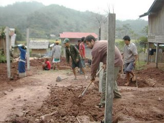
Things got off to a start on Monday morning when Vixay, Khonsevan, and I headed out to Ban Bo. We arrived in the village about an hour late as it took awhile to round everyone up, get all the materials in the truck and drive out to the village. When we arrived we were informed by the village representative for the Lao Women’s Union, Mrs. Haak, that none of the villagers had shown up for the training, but that she would do her best to go and round some up for us…such enthusiasm! The three of us unloaded the truck at the village temple where we were to conduct the training and then sat around waiting for people to show up for another 60 minutes or so. (This kind of thing is perfectly normal…so I wasn’t too worried.)

Finally, 10 people…7 women and 3 men, showed up and we got started. First thing we did was mix the sand, gravel and concrete to pour our first mould. This went quickly enough though I was starting to fret when the villagers and my Lao trainers put far to much water into the cement mix (the mix for the BSF is supposed to be fairly dry or the water runs out the bottom of the mould taking the cement with it leaving nothing but sand and gravel, which typically falls apart almost immediately.) Again, I wasn’t too worried as I feel it’s best for these kinds of mistakes to be made during the training when I can deal with them rather than after. After we poured the mould I spent the rest of the day giving instruction on how the filter works, water storage, and basic sanitation with lots of games and activities to help the villagers understand….generally a good time.

The next morning (Tuesday) we arrived at the temple (Wat in Lao) and proceeded to extract the concrete case we poured the day before. As expected, the case cracked and literally fell apart in front of us into about a thousand pieces. I wasn’t worried, but I did not expect the villager’s reaction…when they saw how bad it turned out it seemed like most them lost interest in continuing. It took some fast talking on my part to assure them this was normal. We discussed what went wrong, what we could do better, and I managed to convince them to pour a second mould. We did so, but I could see that any additional lecturing or activities was out of the question until they saw how this mould turned out. So, we agreed to leave the cement dry for an extra day and return on Thursday afternoon for the extraction. I was praying it would turn out this time or else I wasn’t sure what we would do.

Thankfully, when we returned on Thursday and extracted the case it came out beautiful…no cracks, only a few leaks, and the energy of the villagers turned up immediately. In fact, with no prompting from me or my colleagues, the villagers jumped right in and poured a new mould within 30 minutes. I was hoping to do some more training, review what we had discussed the day before, etc, but this was not to be…the women felt it was time for us to…well, drink. So, next thing I knew I was sitting at someone’s house trying out the local Lau Lao (local rice whisky equivalent to moonshine—in fact Ban Bo is exceptionally well known in the area for making high quality Lau Lao, although it really all tastes the same to me.) During the ongoing discussion I learned some interesting facts concerning the villagers understanding and perceptions of our project. Just to review quickly: this project, funded by the German Agro Action to the tune of $2400 US, was to build a gravity fed water system and to train the villagers to build, maintain and use the BioSand Water Filters to produce cleaning drinking water. It’s important to note that both these activities were at the request of the villagers. We have met numerous times with the villagers, and thought we had made it very clear what each part was for: water system was for delivery and the BSF for making clean water. Problem is, as I found out, over one glass of lau lao after the other, that the villagers assumed that any water that comes out of a pipe, is already clean, and they were confused about what exactly the BSF was for and why they needed it. Eeep! Hadn’t they asked us for it? So, I knew right then that we had a communication problem and are looking at months of follow up to clear up the misconceptions. Nevertheless, the people in the workshop assured us they were very excited about the BSF and wanted to learn more. At least we had that going for us.

Sunday, now a week gone by when I had hoped to finish by Wednesday, we returned in the afternoon to see how the third case turned out and to hopefully train the participants to prepare and install the filter medium (gravel and sand). The second case turned out even better than the second one and I could see the workshop participants were starting to get excited about the possibilities. After pouring yet another mould, we got started on installing the filter mould. Now, anybody who has seen my office and I working on the BSF before, will know we’ve experienced some difficulties in this area. If the filter media, layers of sand and gravel, are installed correctly, the water should flow out of the filter at 1 liter/minute. If it comes out to fast, this means the medium was installed incorrectly, the water is not getting filtered and the water is not safe to drink. It all comes down to a matter of what kind of sand you use and how you prepare it. If the sand comes from the local river (as is the case it Ban Bo), it is usually mixed heavily with clay and other materials, and is likely contaminated with bacteria requiring it to be sterilized (boiled) and washed (too remove the clay). Problem is, during this process, if the sand is cleaned too well, the water will practically shoot out of the filter like a fire hose. If it is not cleaned enough, it clogs up the filter like a cork and no water comes out at all. So it is a matter of finding the perfect balance…a process that usually takes a fair amount of practice and can be a source of frustration and discouragement for the villagers, and requires a huge amount of follow up and additional training from the trainers. Understandably then, it was with some trepidation and anxiety on my part when we finished installing the medium, that we prepared to test the water flow. This involves taking a 1 liter bottle and a stop watch, filling the filter with water, and then counting the seconds until a minute passes.

Important sidebar: as any one who has traveled in Asia generally, and Lao in particular, you will understand the important role that Buddhism plays in blessing all community events and situations (i.e. weddings, new babies, even new motorcycles, etc.). The training we were conducting was in fact taking place on the grounds of the village temple. The filter we were about to test was set up just off to the side of the front doors. Neither myself, my colleagues, nor the villagers had considered asking the monks to bless the BSF, but we were about to experience the positive benefits of even having them around. As we prepared to test the filter, dusk was starting to fall around us. At every temple throughout Lao, just before dark, the monks begin their evening prayers by gathering and playing a large drum by the temple along with sets of chimes and gongs. Basically, a little pre-dinner jam session. I gave the bottle to Khonsevan, and got my cell phone turned on to the stopwatch. Just as did this, the monks started into their first song: at first slow with a steady drum and steady chimes, the gong setting the backbeat. I counted to three and Khonsevan let the water start flowing into the bottle. The monks kicked up the beat. Everyone gathered around holding a collective breath. At 24 seconds the bottle was at the quarter mark. Good sign. The music picked up in tempo, the drummer was really starting to bang it out, the gong going strong, the chimes clanging away. 30 seconds, the bottle was a little over half full. Damn, it was coming out a bit fast. I could feel sweat running down my face. I was counting along with the clock. Suddenly, the monks slowed down the tempo…and you may not want to believe this…but I swear to Buddha, the water flow seemed to slow with it. 45 seconds and sure enough, the bottle was at ¾ full. The rhythm was steady and filling. At this point I was praying to Buddha himself. Come on fat boy, show me some of that sweet enlightenment baby! 50 seconds and the water was just about at the top of the bottle. I was worried…If this didn’t work out and we had to redo the filter medium I could see the villagers throwing up their hands and walking off…no filters for this village. The monks really kicked up the beat for the crescendo! Boom boom boom. Everyone was silent and then the bottle was full. The monks stopped with one final bang. I stopped the clock afraid to look. I stepped back with everyone staring at me. I looked at the clock and the final mark was 1 minute 7 seconds! Good enough. I yelled out the time and the crowd erupted and the monks cheered and really kicked into a jam….people started dancing and “nopping” (clasping their hands in front of their faces and bowing) to the filter. Personally, I give full credit to the villagers for preparing the sand and the monks for the musical talents and connection to another world behind this world for sure. The lau lao flowed and I managed to make it home before dark with my broken headlight…but at least the training ended on a good note. I will never underestimate the power of Buddhist blessings again. Hopefully we won’t have to have celestial jam session going every time they build a new filter or simply want to use it!

We still have to do a lot of work to finish up the training: checking how they are making new filters, do some work around promotion and selling, clearing up the misconception between the water system and the BSF and clean water, but I am very confident the villagers will be making many units well into the future. Not too bad overall.

Out of town on study tour

Hey all, so tomorrow I will be headed out with my office colleagues and some village residents from the Nam Ko area on a study tour to Luang Phabang and Houaphanh Province. We will be visiting some projects involved in community forest management and watershed management. I will be gone until next Saturday, October 28 and will most likely not have any access to the internet during that time. cheers all.